









Map layers · 19 layers
Infrastructure, layer by layer over the property.
The Infrastructure category brings together technical infrastructure such as bridges, power grids, water and sewer pipes, broadband, public transport stops and administrative boundaries. The layers help you map what exists in and around a plan area, assess connection options and identify infrastructure that may affect a development.
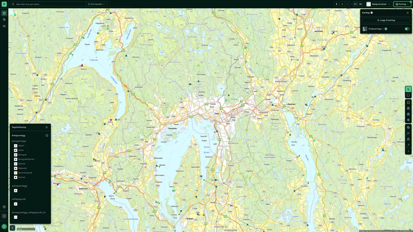
The layers
19 infrastructure layers
| Layer | Description | Source |
|---|---|---|
| Bridges | Planned, newly built, demolished, trafficked and closed bridges | Statens vegvesen |
| Broadband coverage | Broadband coverage for buildings by speed class | Geodata AS |
| Fibre coverage | Share of households offered fibre at 1 Gbit/s | Nasjonal kommunikasjonsmyndighet (Nkom) |
| Counties' borders | County codes and boundaries | Kartverket. Datasets: Counties' borders |
| Municipality Borders | Municipality codes and boundaries | Kartverket. Datasets: Municipality Borders |
| Infrastructure buildings | Buildings with an infrastructure purpose | Kartverket |
| Fuel stations | Chain affiliation, employees and accounts | Geodata AS. Datasets: Fuel stations |
| Post offices and postal locations | Post offices and postal locations. | Geodata AS. Datasets: Post offices and postal locations |
| Grid installations | Electric lines, cables and transformer stations | Norges vassdrags- og energidirektorat |
| Planned Electrical Installations in the Power System | Planned power lines and facilities | Norges vassdrags- og energidirektorat (NVE). Datasets: Planned Electrical Installations in the Power System |
| Wind power | Licensed wind farms | Norges vassdrags- og energidirektorat (NVE) |
| Hydropower | Developed and planned hydropower | Norges vassdrags- og energidirektorat (NVE) |
| Substations, towers, poles & licences | Transformers, masts, poles and licences | Norges vassdrags- og energidirektorat (NVE) |
| Public transport stops | Bus, metro, tram, train and ferry/port | Entur |
| NADAG – ground investigations | National database of geotechnical ground investigations | Norges geologiske undersøkelse (NGU). Datasets: NADAG – ground investigations |
| Petroleum Infrastructure | Pipelines, platforms and onshore facilities | Geodata AS |
| Water & sewer assets along roads | Water and sewer manholes and structures along roads | Statens vegvesen |
| Wastewater facilities | Municipal wastewater discharges | Miljødirektoratet. Datasets: Wastewater facilities |
| Manhole cover, drain and hydrant | Visible water and sewer infrastructure on the ground surface | Norges vassdrags- og energidirektorat |
Layer by layer
What each layer shows
Bridges
Planned, newly built, demolished, trafficked and closed bridges from NVDB. Useful for mapping access conditions to a property and for identifying whether planned measures depend on a bridge with limited capacity or weight limits. Planned, newly built, demolished, trafficked, non-trafficked and closed bridges. The map layer is based on data from NVDB (the national road database). Included use categories: Road bridge (12k) Bridge in embankment (5k) Tunnel/road canopy (2k) Pedestrian and cycle bridge (1.5k) Retaining structure (1k) Ferry berth (600) Railway bridge (230) Other structure category (200)
Broadband coverage
Broadband coverage for buildings, grouped into speed classes, from Nkom (Nasjonal kommunikasjonsmyndighet). Useful for commercial property assessments where broadband capacity is critical (data centres, office buildings, logistics terminals), and for residential assessments in rural areas where fibre coverage varies. Shows broadband coverage for buildings, grouped into different speed classes. The coverage map is based on data reported by broadband providers to Nkom's coverage survey. Note that the map may contain errors in some cases. Read more about broadband coverage at Nkom: Nkom – Bredbånd i Norge 2022
Fibre coverage
Share of households offered fibre at 1 Gbit/s, from Nkom's coverage survey. The layer has five views: household points, 250 m and 1000 m grids, municipality and county. Darker green means a higher share. The layer shows where fibre is offered, not who supplies it. Nkom publishes coverage aggregated across providers, and no open source names the supplier at an address. Use it to see whether an area has been built out, not to decide who to call.
Counties' borders
An overview of the counties, their codes and boundaries. Data from Kartverket. The map layer gives an overview of the counties, their codes and boundaries.
Municipality Borders
An overview of the municipalities, their codes and boundaries. Data from Kartverket. The map layer gives an overview of the municipalities, their codes and boundaries.
Infrastructure buildings
All building types associated with infrastructure, from the matrikkel. Shows all building types linked to infrastructure from the matrikkel. Building geometry comes from FKB. Transport Traffic supervision building Lighthouse station, pilot station Railway and metro station Other dispatch and terminal building Dispatch building, air terminal, control tower Other road and traffic supervision building Water and sewage Building for water supply Building for treatment plant Public toilet Parking Other garage/hangar building Multi-storey car park
Fuel stations
Chain, number of employees and accounts (also in Business). Data from Geodata AS. Chain, number of employees and accounts where available. Weekly updates when the owner updates.
Post offices and postal locations
An overview of post offices, Post i Butikk, parcel lockers and postal locations. Data from Geodata AS. Shows post offices, post in store and other postal locations in Norway. The dataset covers both dedicated post offices and postal locations at grocery chains. Supplied by Geodata AS, with Enhetsregisteret as the source for the company details.
Grid installations
All lines, cables and substations registered in Netbas (Volue), the national power grid register. Includes the distribution grid, regional grid, transmission grid, subsea cables, towers and poles. Identical to the layer in Energy. Datasets: Grid installations. Digitised lines, cables and substations in Netbas (publicly available data only). Updated continuously by NVE.
Substations, towers, poles & licences
Substations, towers, poles and licences from Norges vassdrags- og energidirektorat (NVE). Datasets: Substations, towers, poles & licences. The location of substations, towers/poles and related licences from NVE's grid installation dataset (public subset). Weekly updates when the owner updates.
Public transport stops
Bus, metro, tram, train and ferry/port from Entur. Shows the physical location of stops and stations. Also available in Transport and communications and part of the Family and accessibility combination in Map layer. Datasets: Public transport stops. Bus, metro, tram, train and ferry/port stops from Entur. Weekly updates when the source updates.
NADAG – ground investigations
The national database for geotechnical ground investigations from Norges geologiske undersøkelse (NGU). Shows the location of boreholes, sampling and stability analyses carried out by municipalities, Statens vegvesen and private parties. Useful for seeing whether existing geotechnical data are available on or near a plot, which can reduce the cost of a new ground investigation. The national database for geotechnical investigations (boreholes), operated by NGU in cooperation with partners. The amount of information per data point varies depending on the supplier.
Petroleum Infrastructure
A detailed representation of petroleum infrastructure in Norway. Data from Sokkeldirektoratet (formerly Oljedirektoratet). Datasets: Petroleum Infrastructure. The map layer gives a detailed representation of petroleum infrastructure in Norway, with key facilities and pipelines that are essential to the oil and gas industry.
Water & sewer assets along roads
Water and sewer data from NVDB: manholes and structures along roads. Selected NVDB objects related to water and sewage (manholes, pipelines, pipe trenches, ditches, toilet facilities). Weekly updates based on the latest NVDB data.
Wastewater facilities
An overview of municipal wastewater discharges. Data from Miljødirektoratet. Overview of discharges of municipal wastewater (KOSTRA reporting). Updated continuously by Miljødirektoratet.
Manhole cover, drain and hydrant
The pipe network visible at ground level. Data from Norges vassdrags- og energidirektorat (NVE). Datasets: Manhole cover, drain and hydrant. Contains the pipe network that is visible at the ground surface (manhole cover, drain and hydrant), not the complete pipe network. The map layer is based on LedningVA from FKB.
Planned Electrical Installations in the Power System
Electrical installations and power lines that have not been built. Data from Norges vassdrags- og energidirektorat (NVE). Planned electrical installations in the power system The map layer shows electrical installations and power lines that have been granted a licence or are at various stages of licence processing, but that have not yet been built. Each object is assigned one of the following statuses:
Wind power
Wind power plants subject to licensing, processed by Norges vassdrags- og energidirektorat (NVE). Datasets: Wind power. Wind power plants subject to licensing that NVE has finished processing, including installations under construction and in operation. Weekly updates when owners update.
Hydropower
Developed and undeveloped hydropower as managed by Norges vassdrags- og energidirektorat (NVE). Datasets: Hydropower. Developed and undeveloped hydropower installations, dams and regulated lakes as managed by NVE, including licence processes and remaining potential.
The datasets behind
Datasets in Infrastructure
Fuel stations
All fuel stations in Norway with chain affiliation (Circle K, Shell, Esso, YX, Best, Uno-X and others), number of employees and accounts data.
About the datasetBroadband coverage
Broadband coverage per building, grouped into speed classes.
About the datasetBridges
All bridges and bridge-like structures in Norway, taken from the Norwegian Public Roads Administration's National Road Database (NVDB): planned, newly built, demolished, in use, not in use and closed or blocked.
About the datasetFibre coverage
Share of households offered 1 Gbit/s fibre, from Nkom's annual coverage survey.
About the datasetMunicipality Borders
Norway's 357 municipalities with municipality number (four-digit code) and official outer boundaries.
About the datasetManhole cover, drain and hydrant
Visible points on the municipal water and sewage network: manholes, gullies and fire hydrants, taken from LedningVA in Felles kartdatabase (FKB).
About the datasetPost offices and postal locations
Locations of post offices and post-in-shop outlets in Norway.
About the datasetWater & sewer assets along roads
Selected water and sewer assets along public roads from Statens vegvesen's National Road Database (NVDB).
About the datasetHow do I turn on the infrastructure layers in Fusion?
Click Map layers at the top right of the map, select the category in the list on the left and turn on the layer. You can have several layers on at once, over the same property.
Where do the layers come from?
The sources are listed in the table above. They include Statens vegvesen, Geodata AS, Nasjonal kommunikasjonsmyndighet (Nkom) and Kartverket. Datasets: Counties' borders. Each layer shows its source and date.
Can I get the same data programmatically?
Yes. The datasets behind the layers are available in the Placepoint API and in Placepoint AI through MCP.
Other categories
The layers and descriptions come from the documentation, synced 16 October 2026.
Used where decisions really matter







