









Map layers · 14 layers
Buildings, layer by layer across the property.
Map layers covering the building stock and its physical and legal properties. The category contains 14 layers covering shelters, environmental certifications, energy labels and related datasets.
The layers
14 layers in Buildings
Open the category with the Map Layers button at the top right of the map, or through Map layers in the left-hand menu, and select Browse layers. Click the Buildings tile to open the sublist.
| Layer | Description | Source |
|---|---|---|
| Public Shelters | Public shelters in Norway. Shelters are permanent protective rooms intended to protect the population against harm from acts of war. | Norwegian Directorate for Civil Protection |
| Environmental Certifications | This map layer contains information on 3 certification types: BREEAM, Svanemerket (Nordic Swan Ecolabel) and LEED. | Building Research Establishment (BRE) |
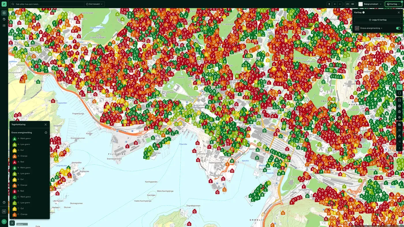
| Enova Energy Labelling | This map layer contains Enova's energy certificates, made up of an energy rating and a heating rating. | Enova SF |
| Commercial buildings | Shows all building types associated with business use, from the matrikkel. | Kartverket |
| Apartment building | Shows all building types associated with housing, from the matrikkel. | Kartverket |
| Public and similar buildings | Shows all building types associated with public or similar buildings, from the matrikkel. | Kartverket |
| Sports, culture & religious buildings | Shows all building types associated with sports, cultural and religious buildings, from the matrikkel. | Kartverket |
| Agriculture and fisheries buildings | Shows all building types associated with agriculture and fisheries, from the matrikkel. | Kartverket |
| Infrastructure buildings | Shows all building types associated with infrastructure, from the matrikkel. | Kartverket |
| Developer activity | Shows areas where new activity is under way or planned in the near future (building alterations are not included). The data is based on information from the matrikkel. | Kartverket. Dataset: Developer activity |
| Coverage Map Case Access | Shows all municipalities where we collect postlister (public mail records), with population and the number of documents available. | Placepoint |
| Building age | This map layer gives a detailed picture of building age across Norway, using data from the matrikkel. Building geometry comes from FKB. | Kartverket. Dataset: Building age |
| Fuel stations | Contains information on chain, number of employees and accounts. | Geodata AS |
| Shopping centres | Shown by size of total revenue (where available). | Geodata AS |
Layer by layer
What each layer shows
Public Shelters
Public shelters in Norway. Data from Direktoratet for samfunnssikkerhet og beredskap. Public shelters in Norway. Shelters are permanent protective rooms intended to protect the population against harm from acts of war. Public shelters serve the population in an area and have been built in cities and larger urban areas, and in residential areas where the coverage of private shelters is not satisfactory.
Environmental Certifications
Information about three certification types: BREEAM, Svanemerket and LEED. BREEAM has gained a strong foothold in Norway and is the most widely used system for commercial buildings. Data from Building Research Establishment (BRE). The map layer contains information about three types of certification: BREEAM BREEAM has gained a strong foothold in Norway. The BREEAM family of certification schemes is managed by the Building Research Establishment (BRE) in the United Kingdom. BREEAM-NOR is a Norwegian adaptation and is today Norway's most used environmental certification for new builds and major refurbishments. Sustainability is increasingly central in construction projects. As a client or developer, you cannot disregard this. Your construction project will be measured on these factors, both for financing and by potential buyers or tenants. Building to BREEAM-NOR shows that the project has qualities beyond the minimum requirements of the building regulations and has taken account of values that society cares about. Read more.. Svanemerket Svanemerket is a good tool for constructing buildings that are better choices for the environment, the climate and everyone who spends time in them. The requirements emphasise resource efficiency, lower climate impact, a more circular economy without environmental toxins and the conservation of biodiversity. They also promote buildings with a good indoor climate and high quality. The Svanemerket requirements are also a good tool for demonstrating compliance with Annex 1 of the EU taxonomy for the construction of new buildings. Read more.. LEED Leadership in Energy and Environmental Design (LEED) is a green building certification programme used worldwide. It was developed by the non-profit U.S. Green Building Council (USGBC) and includes a set of rating systems for the design, construction, operation and maintenance of green buildings, homes and neighbourhoods. The purpose is to help building owners and managers act with environmental responsibility and use resources efficiently. LEED is a design tool rather than a performance measurement tool and focuses on energy modelling rather than actual energy use. It lacks climate specificity and has been criticised for a points system that can encourage unsuitable design choices and make energy saving the weakest part of the evaluation. Read more..
Enova Energy Labelling
Enova's energy performance certificates, consisting of an energy rating and a heating rating. Data from Enova SF. This map layer contains Enova's energy performance certificates, consisting of an energy rating and a heating rating. The energy rating runs from A to G, where A is the best. The rating indicates the energy standard of the building itself and of the heating system. The heating rating is a colour scale from red to green, where green is best. A good heating rating means that a large share of the home can be heated with something other than oil, gas and electricity. The certificates are valid for 10 years from the date of issue, or until they are replaced by a newer certificate. The energy performance certificate is a public document. It is based on the information registered when the certificate was issued. Enova is not responsible for the accuracy of that information. Normally, the most recently registered certificate applies.
Commercial buildings
All building types linked to business use from Matrikkelen. The layer has both area and point versions. Shows all building types linked to business use from the matrikkel. Building geometry comes from FKB. Retail trade Shop building Shopping mall, department store Fuel station Fitness studio Exhibition and congress building Bank building, post office building Industry Factory building Workshop building Other industrial building Central kitchen, canteen building Warehouse and logistics Warehouse hall Other storage building Cold and freezer storage Postal terminal Freight terminal Food and accommodation Camping/rental cabin Hotel building Motel building Hostel, guest house Other hotel building Apartment Other building for accommodation Restaurant building, cafe building Street food outlet, kiosk building Other restaurant building Office Office and administration building, town hall Other office building Media building Other commercial building
Apartment building
All housing types from Matrikkelen. The layer has polygon and point sublayers. Shows all building types linked to housing from Matrikkelen. Building geometry comes from FKB. Residential houses Detached house Farmhouse Farmhouse semi-detached house – vertically divided Farmhouse semi-detached house – horizontally divided Detached house with bedsit/basement flat Semi-detached house Semi-detached house, vertically divided Semi-detached house, horizontally divided Apt. buildings Large detached residential building, 2 floors Large detached residential building, 3–4 floors Large detached residential building, 5 floors or more Large connected residential building, 2 floors Large connected residential building, 3–4 floors Large connected residential building, 5 floors or more Terraced block Townhouse etc. Townhouse Linked/atrium house Other small houses with 3 dwellings or more Holiday Home Cabins, summer houses and similar holiday buildings Garage, outhouse, annex to holiday home Year-round home used as a holiday building Farmhouse used as a holiday building Hostel/holiday home Other Student housing Residential barracks Other residential building (secondary home, reindeer herding) Other building for shared housing
Public and similar buildings
All building types linked to public or similar buildings from Matrikkelen. The layer has polygon and point sublayers. Shows all building types linked to public or similar use from Matrikkelen. Building geometry comes from FKB. School and research Kindergarten Primary school Lower secondary school Combined primary and lower secondary school Secondary school Other university, university college and research building University/university college with auditorium, reading room, etc. Library, media centre Other school building Laboratory building Life and health Residential and treatment centre Residential and service centre Hospital Nursing home Other nursing home Other primary health building Clinic, doctor's office/centre/out-of-hours service/animal hospital Rehabilitation institution, spa Health and social centre, health clinic Fire station, ambulance station Police station
Sports, culture & religious buildings
Building types for sports, culture and religion from Matrikkelen. The layer has polygon and point sublayers. Shows all building types linked to sports, culture and religion from Matrikkelen. Building geometry comes from FKB. Sports Sports hall Stand and sports changing rooms Other sports building Playground Swimming pool Ice rink Culture Nightclub Cinema building, theatre building, opera house/concert hall Museum, art gallery Other cultural centre Other museum and library building Monument Community centre, local hall Zoological and botanical garden Religion Prayer house, parish hall Church, chapel Other building for religious activities Monastery Synagogue and mosque Crematorium, funeral chapel, mortuary
Agriculture and fisheries buildings
Buildings linked to agriculture and fisheries from Matrikkelen. The layer has polygon and point sublayers. Shows all building types linked to agriculture and fisheries from Matrikkelen. Building geometry comes from FKB. Agriculture Greenhouse Building for animals/agriculture, storage/silo Other agricultural building Mountain farm building, hut, fisherman's cabin etc. Forest and outfield cabin, turf hut Fisheries Other fishing and hunting building Operating building for fishing/hunting/aquaculture Boathouse, equipment shed for fishing Boathouse, boat shed, sea shed
Infrastructure buildings
Buildings with infrastructure purposes from Matrikkelen. The layer has polygon and point sublayers. Shows all building types linked to infrastructure from the matrikkel. Building geometry comes from FKB. Transport Traffic supervision building Lighthouse station, pilot station Railway and metro station Other dispatch and terminal building Dispatch building, air terminal, control tower Other road and traffic supervision building Water and sewage Building for water supply Building for treatment plant Public toilet Parking Other garage/hangar building Multi-storey car park
Developer activity
Areas with ongoing or planned building activity (building changes are not included). Data from Kartverket. Areas with ongoing or planned new construction (building changes are not included), based on data from Matrikkelen.
Coverage Map Case Access
Municipalities that Placepoint collects postal lists from, including population figures and the number of documents. Data from Placepoint. Shows all municipalities where Placepoint collects postal lists, together with population figures and the number of available documents. Municipalities with postal lists let you go directly to case access from any property and monitor case access in projects.
Building age
A detailed picture of the age of buildings across Norway, based on data from Matrikkelen. Building geometry comes from FKB. Data from Kartverket. The map layer gives a detailed picture of the age of residential buildings across Norway, based on data from Matrikkelen.
Fuel stations
Fuel stations with information about chain, number of employees and accounts. Data from Geodata AS. The layer contains one sublayer: Shops.
Shopping centres
Shopping centres shown by size of total revenue, where available. Data from Geodata AS. The layer has two sublayers: Operations and owners, and Shopping mall.
How do I turn on the Buildings layers in Fusion?
Click Map layers at the top right of the map, select the category in the list on the left and turn on the layer. You can have several layers on at once, over the same property.
Where do the layers come from?
The sources are listed in the table above, including Direktoratet for samfunnssikkerhet og beredskap, Building Research Establishment (BRE), Enova SF and Kartverket. Each layer shows its source and date.
Can I get the same data programmatically?
Yes. The datasets behind the layers are available in the Placepoint API and in Placepoint AI through MCP.
Other categories
The layers and descriptions come from the documentation, synced 16 October 2026.
Used where decisions really matter







