









Map layers · 21 layers
Nature, layer by layer over the property.
The Nature category brings together layers for species observations, mapped nature types, outdoor recreation interests and legal protection boundaries such as the Marka boundary and the Shoreline management zone. Use the layers in planning assessments and zoning work to find nature considerations that could lead to a formal objection from the Statsforvalteren (county governor). You can also use them to assess the quality of outdoor recreation in an area.
The layers
21 layers in Nature
| Layer | Description | Source |
|---|---|---|
| Sensitive species data | Sensitive occurrences of birds, mammals and lichens | Miljødirektoratet. Datasets: Sensitive Species Data |
| Outdoor recreation areas | Outdoor recreation areas valued using the national method | Miljødirektoratet |
| NiN mapping units | Nature types mapped using the NiN system | Miljødirektoratet. Datasets: NiN mapping units |
| Species of national management interest | Species map for management use | Miljødirektoratet. Datasets: Species of national management interest |
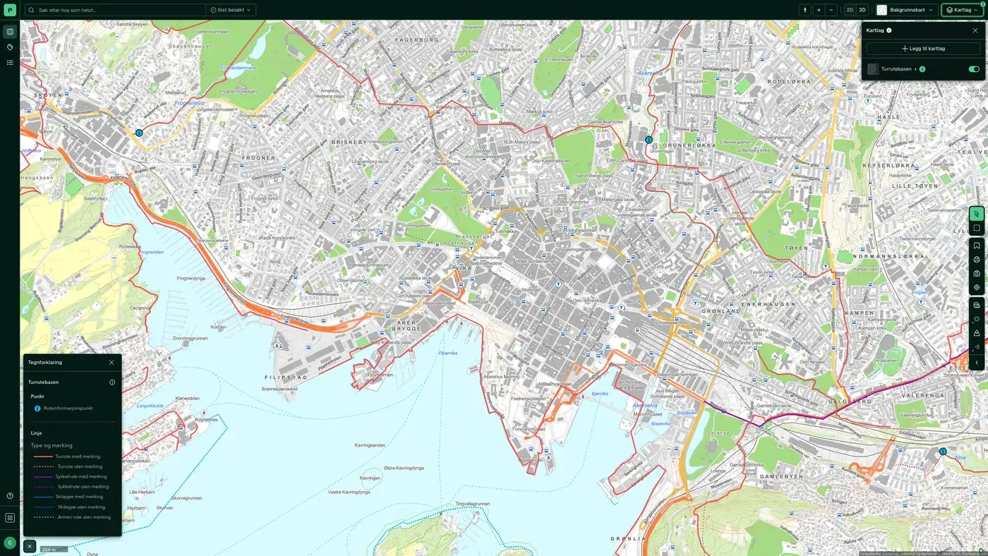
| The route base | Hiking routes, ski trails and cycle routes | Kartverket |
| The species database | Species observations in Norway | The species database |
| Nature and cultural areas | Selected cultural landscapes with dedicated management efforts | Miljødirektoratet. Datasets: Nature and cultural areas |
| Marka boundary | Boundary under the Marka Act for Oslo and the surrounding area | Miljødirektoratet |
| Shoreline management zone | The 100-metre belt along the sea and watercourses | Kartverket |
| Land cover type | The main classification in AR5 is land type, based on criteria for vegetation, natural drainage and human influence. | Norsk institutt for bioøkonomi (NIBIO) |
| Reindeer husbandry | Reindeer husbandry takes place in almost 140 of the country's municipalities, on an area covering about 40% of Norway's land area. | Landbruksdirektoratet |
| Arable land | Shows areas that, if cultivated, can be prepared to meet the requirements for fully cultivated land, and that meet the climate and soil quality requirements for growing crops. | Norsk institutt for bioøkonomi (NIBIO) |
| Aquaculture register | The Aquaculture register contains an overview of aquaculture licences and the decisions related to them. | Fiskeridirektoratet |
| Restricted zones in protected areas | Bans on access, landing and low-level flying, with legal basis | Miljødirektoratet |
| Snowmobile trails | Adopted and planned trails, and which municipalities have submitted them | Miljødirektoratet |
| State-secured recreation areas | Areas the state has secured through purchase or agreement | Miljødirektoratet |
| Outdoor recreation in protected areas | Protected areas that are also registered as outdoor recreation areas | Miljødirektoratet |
| Landscape types, NiN | Landscape types under Nature in Norway (NiN), divided by landform, water and vegetation | Miljødirektoratet |
| Grey areas | Nationwide map of grey areas: land already in use or heavily affected by building and construction activity, including buildings, structures and permanent surfaces | Norsk institutt for bioøkonomi (NIBIO) |
| Valued nature types | Nature type sites valued using the criteria in guidance M-1941 for impact assessments, from very high value to some value | Miljødirektoratet |
| Large carnivore management zones | Miljødirektoratet's boundaries for the management areas for bear, Eurasian lynx, wolverine and wolf | Miljødirektoratet |
Layer by layer
What each layer shows
Sensitive species data
Database of sensitive occurrence data for selected birds, mammals and lichens from Miljødirektoratet. "Sensitive" means that the exact location is shielded to protect against disturbance. The layer shows coarse polygons, not point locations. Relevant for planning work near known breeding sites or growing sites for red-listed species. Sensitive species data is a collective term for a database of selected species of birds, mammals and lichens where located information about the species' breeding area, nesting area or growing site is shielded from public access. The reason is that open access could expose the species or the site to harmful effects, such as disturbance, persecution or destruction. The data is published through a password-protected solution that shows the exact location of the objects. The county governor and Miljødirektoratet can grant access. The data is also available through an open solution that shows masked data in the form of grid cells of varying size depending on the species. Area of use The dataset is suitable for use in all types of land use planning and land management tasks, including individual case processing. It should also be used when planning and carrying out logging and other commercial activity that can affect occurrences of sensitive species. Access Even though information about sensitive species is not openly available, public administration, developers, consultancies and others with legitimate needs can get access to relevant data for the area or project in question. Access is granted through password protection and rights management. The county governor can grant access for municipalities and other users within the county. Miljødirektoratet can grant access where there is a need across county boundaries or nationally. The document "Retningslinjer for håndtering av sensitive artsdata" covers species, assessments and case processing. Information without an exact location is available to everyone through a viewing solution with masked data. The WMS service is publicly available. The mask size varies between different species; some have such extensive masking that relatively large areas are marked on the map. Knowledge of the species' biology will make it easier to assess whether the exact location is needed in the specific case.
Outdoor recreation areas
Shows areas mapped and valued using Miljødirektoratet's national methodology for outdoor recreation mapping. The municipalities have mapped and valued outdoor recreation areas (very important, important, registered). Development in very important outdoor recreation areas can trigger an objection. Areas mapped and valued using Miljødirektoratet's guide M98-2013, to show places that are important for public outdoor life.
NiN mapping units
Nature types mapped at scales of 1:5,000 and 1:20,000 using the NiN system (Natur i Norge). NiN is the nationally recognised methodology for classifying nature types on land and in fresh water. Nature types with high value (A and B) provide grounds for objection under T-2/16. The dataset is managed by Miljødirektoratet. Nature mapping using the Natur i Norge (NiN) v2 system, with converted v1 data; projects approved and published through Miljødirektoratet's data flow.
Species of national management interest
Management-oriented species map from Miljødirektoratet showing occurrences of threatened and near threatened species (CR, EN, VU and NT on the red list), priority species and selected nature types. The dataset is compiled from Artsdatabanken and municipal mapping, and is used actively by the county governor in objection cases. Management-oriented map distributed by Miljødirektoratet, where all data collection is based on the species data flow established by Artsdatabanken. Since 2005, Artsdatabanken has established data flows with relevant institutions and databases. Data ownership is clarified and rests with the original host. The dataset covers both species that need protection and harmful (alien) species. All relevant species groups are included. The decision to include is mainly taken on the basis of relevant statuses such as threatened species, responsibility species and protected species. In addition, two quality parameters are required: geographical precision and function (activity). These requirements vary between different species groups. Mapped occurrences of sensitive functional areas for given species are not included in this dataset.
The route base
Nationwide overview of hiking routes, ski trails, cycle routes and walking routes. Data from Kartverket / DNT. Useful for assessing recreational value and access to outdoor life from a property, and for seeing whether planned measures cross important hiking paths. Nationwide overview of hiking routes, ski trails, cycle routes and other routes, as well as facilitation measures in outdoor recreation areas. The data can be used in processes under the Planning and Building Act, for analyses, reporting and trip planning.
The species database
Species observations registered in Artsdatabanken, Norway's national database for biological diversity. Shows dated records of plants, animals and fungi. Useful as a supplement to Species of national management interest, but remember that observations can be old and the location accuracy varies. Datasets: The species database. This map layer contains information about species observed or registered in Norway, supplied by Artsdatabanken. It includes data on individual observations, red list categories and categories for alien species.
Nature and cultural areas
Shows selected cultural landscapes with a dedicated management scheme from Miljødirektoratet. Selected cultural landscapes in agriculture is a national scheme for preserving valuable cultural landscapes, and plans that threaten these can meet resistance in the planning process. Cultural landscapes - selected
Marka boundary
Shows the boundary for the scope of markaloven (the act on nature areas in Oslo and neighbouring municipalities). Inside the Marka boundary, measures that can harm the natural environment are prohibited; building and construction measures are as a rule prohibited without an exemption. Relevant for all plots in and near Marka in the Oslo region. Data from Miljødirektoratet. Datasets: Marka boundary. Legal delimitation of Oslo Marka under the Marka Act of 2009 and the regulations of 2015 (with adjustments from 2019).
Shoreline management zone
Shows the 100 metre belt along the sea and watercourses where, under the Planning and Building Act section 1-8, measures are prohibited without a municipal exemption. The state planning guidelines for the shoreline zone (SPR) tighten the protection along the Oslofjord and in southern and western Norway. The layer gives a visual answer to whether a property is affected by the shoreline zone provisions. Data from Kartverket. Datasets: Shoreline management zone. National planning guidelines for differentiated management of the 100-metre belt along the sea.
Restricted zones in protected areas
Areas within protected areas where access, landing or low flying below 300 metres is prohibited, with the legal basis for each restriction. The armed forces' own exemptions are in separate layers. The restrictions apply to activity, not land use, so they come in addition to the protection provisions for the area. Source: Miljødirektoratet. Areas within protected areas where access, landing or low flying is prohibited, with the legal basis for each restriction. The armed forces' own exemptions are in separate layers. Source: Miljødirektoratet.
Snowmobile trails
Adopted and planned snowmobile trails, with a separate layer showing which municipalities have reported trails. Relevant for noise and traffic near cabin and rental property, where a trail close by can affect both use and value. Source: Miljødirektoratet. Adopted and planned snowmobile trails, with a separate layer showing which municipalities have reported trails. Relevant for noise and traffic near cabin and rental property. Source: Miljødirektoratet.
State-secured recreation areas
Areas the state has secured for outdoor life through purchase or agreement, with the form of securing and the year. The parcel boundary points show how the area is delimited. The securing follows the property and limits what it can be used for. Source: Miljødirektoratet. Areas the state has secured for outdoor life through purchase or agreement, with the form of securing and the year. The parcel boundary points show how the area is delimited. Source: Miljødirektoratet.
Outdoor recreation in protected areas
Protected areas that are also registered as outdoor recreation areas, with the form of protection and the management authority. Shows where protection and outdoor life apply to the same area, which determines who you apply to when a measure affects the area. Source: Miljødirektoratet. Protected areas that are also registered as outdoor recreation areas, with the form of protection and the management authority. Shows where protection and outdoor life apply to the same area. Source: Miljødirektoratet.
Landscape types, NiN
Landscape types under Natur i Norge, which divides the country into types based on landform, water and vegetation. A basis for describing what kind of landscape a property lies in, for example in an impact assessment. The layer is drawn from 1:1,000,000 and closer. Source: Miljødirektoratet. Landscape types under Natur i Norge, which divides the country into types based on landform, water and vegetation. A basis for describing what kind of landscape a property lies in. Source: Miljødirektoratet.
Grey areas
Nationwide map of grey areas: areas that are already in use or strongly affected by building and construction activity, including buildings, structures and permanent surfaces. Separate views for the share with buildings and the share with/without vegetation. Nationwide map of grey areas: areas that are already in use or strongly affected by building and construction activity, including buildings, structures and permanent surfaces. Separate views for the share with buildings and the share with/without vegetation. Developed by Miljødirektoratet, Kartverket, NIBIO and SSB. Source: Miljødirektoratet.
Valued nature types
Nature type localities valued using the criteria in guide M-1941 for impact assessments, from very high value to some value. Brings together valued localities across the mapping methods (Miljødirektoratet's instruction, DN-håndbok 13 and 19). Nature type localities valued using the criteria in guide M-1941 for impact assessments, from very high value to some value. Brings together valued localities across the mapping methods (Miljødirektoratet's instruction, DN-håndbok 13 and 19). Source: Miljødirektoratet.
Large carnivore management zones
Miljødirektoratet's boundaries for the management zones for bear, lynx, wolverine and wolf. Inside the zones the species are to breed, outside them grazing animals take priority, which governs compensation, damage culling and land use. Miljødirektoratet's boundaries for the management zones for bear, lynx, wolverine and wolf. Inside the zones the species are to breed, outside them grazing animals take priority, which governs compensation, damage culling and land use.
The datasets behind
Datasets in Nature
Species of national management interest
Species of national management interest is a management dataset of species that have some form of national status: threatened species (Red List), responsibility species (Norway has a particular management responsibility for them), protected species and invasive alien species.
About the datasetThe species database
Species observations and Red List assessments from Artsdatabanken, Norway's national knowledge bank for biodiversity.
About the datasetLarge carnivore management zones
Miljødirektoratet's boundaries for the management areas for bear, Eurasian lynx, wolverine and wolf.
About the datasetOutdoor recreation in protected areas
Protected areas that are also registered as outdoor recreation areas, with protection type and management authority.
About the datasetGrey areas
A national map of grey areas: land that is already in use or heavily affected by building and construction, including buildings, structures and permanent surfaces.
About the datasetOutdoor recreation areas
Areas mapped and valued using the method in Miljødirektoratet's guide M98-2013 "Kartlegging og verdsetting av friluftslivsområder" (mapping and valuing outdoor recreation areas).
About the datasetNiN mapping units
Nature areas mapped using Natur i Norge (NiN), Artsdatabanken's standard system for classifying and describing Norwegian nature.
About the datasetLandscape types, NiN
Landscape types under Natur i Norge, which divides the country into types based on landform, water and vegetation.
About the datasetMarka boundary
The Marka boundary defines the area covered by the Marka Act (Act of 6.
About the datasetHow do I turn on the Nature layers in Fusion?
Click Map layers at the top right of the map, select the category in the list on the left and turn on the layer. You can have several layers on at once, over the same property.
Where do the layers come from?
The sources are listed in the table above, including Miljødirektoratet. Datasets: Sensitive Species Data, Miljødirektoratet, Miljødirektoratet. Datasets: NiN mapping units, Miljødirektoratet. Datasets: Species of national management interest. Each layer shows its source and date.
Can I get the same data programmatically?
Yes. The datasets behind the layers are available in the Placepoint API and in Placepoint AI through MCP.
Other categories
The layers and descriptions come from the documentation, synced 16 October 2026.
Used where decisions really matter







