









Map layers · 0 layers
Zoning, layer by layer over the property.
Map layers linked to municipal plans, zoning plans and the legal framework for land use. The category covers formal plans (zoning plans, municipal plans, area plans) and proposed plans under consideration.
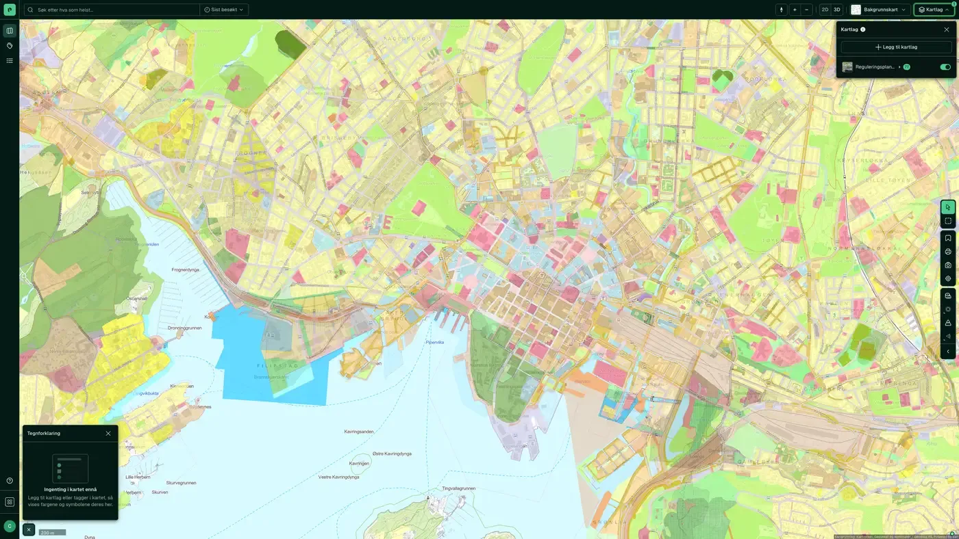
Layer by layer
What each layer shows
Layers in this category (15)
Layer | Description | Source SePlan | GeoNorge's copy of map data from the land-use plan databases of the kommune. Contains plan ID, dates, plan type and plan status from land-use plans. | Kartverket
Zoning Plans
Zoning Plans WMS, the whole of Norway. Data from the kommune. The meaning of the colours and hatching on the plan map is explained in the zoning plan legend. The layer is built as a tree. In the map layer selector in the top right there is an arrow in front of Zoning Plans: click it to expand the vertical levels. Each vertical level expands once more, down to the individual sublayers. The number next to the name shows how many sublayers the level has.
Regulatory Plans (Oslo)
The zoning plans for Oslo kommune. For the legend, see Oslo Kommune Plan- og bygningsetaten. Data from Oslo kommune. This supplements the nationwide Zoning Plans layer, with extra detail specific to Oslo. The layer is organised in three vertical levels: below ground level/tunnel, ground level/water surface and above ground level/bridge. Each level has sublayers for area purpose, restriction zones, designated areas, hazard zones, protection zones, boundaries and legal lines, regulated height, legal points and annotations.
SePlan
GeoNorge's copy of map data from the land-use plan databases of the kommune. Contains plan ID, dates, plan type and plan status. Data from Kartverket. The layer has two sublayers: Zoning plan and Municipal plans.
Mapped municipal plans
Data on the area purpose of the municipality plan, collected continuously by Placepoint from selected kommune. It covers, among others, Bergen (planbeskrivelse for boligforsyning), Hamar (sentrumsplan), Lillestrøm (byutviklingsplan and utnyttelsesgrader) and Oslo (veiledende utnyttelsesgrader). Data from Placepoint. Filtering
Municipal plans
See Municipal plans under the Property category for the full description and sublayers. The municipality plan is the municipality's overarching governing document. It sets the framework for the plans and measures of the municipality's activities, and for the use and protection of land in the municipality. Every kommune must have a municipality plan. A complete municipality plan consists of both a social part with an action programme and a land-use part. Through the municipal planning strategy, the kommune decides whether to carry out a full revision of all parts of the municipality plan, or whether only some parts are to be revised. The municipality plan must safeguard municipal, regional and national goals, interests and tasks, take the municipal planning strategy as its starting point, and be based on guidelines and requirements from national and regional authorities. A municipal sub-plan can be prepared for particular areas, themes or areas of activity. The municipality plan must have an action part that states how the plan is to be followed up over the next four years or more, and it is revised annually. The dataset is generated from the nationwide copy of municipal plans, which is kept up to date with data from the original plan data in the kommune. Updating takes place through periodic copying or synchronisation. Use Land-use planning, case processing under the Planning and Building Act, production of statistics, assessment of measures and projects, and access to the kommune's land-use plan. Only the geographic data (the vector data) of the land-use part is available for download. The associated plan documents are held in the plan registers of the kommune. The geographic data contains links on the plan areas that point to the plan registers, so that the documents are easily available to users. The web application SePlan (seplan.no) gives an overview of available municipal plans nationwide.
Regulation plan proposals
See Regulation plan proposals under the Property category for the full description and sublayers (five vertical levels with area purpose, consideration zones, legal lines, annotations and plan area). The map layer is a geographic information service that gives access to digital map data linked to ongoing or proposed zoning plans in Norway. The map layer makes it possible to explore and analyse information about zoning plan areas, including boundaries, land use, provisions and other relevant geographic data.
Cultural heritage - Askeladden WMS
See Cultural heritage - Askeladden WMS under the Property category for the full description and sublayers (protection zones, localities, individual heritage sites, locality icons, individual monument icons). The display service contains data on archaeological cultural heritage, cultural environments, buildings and technical installations that are protected under the Cultural Heritage Act or the Planning and Building Act. The service also contains cultural heritage sites and cultural environments without formal protection, but registered as locally valuable, as well as world heritage areas and environments.
Housing and area reserve (Oslo)
See Housing and area reserve (Oslo) under the Property category for the full description. Overview of zoned housing capacity in Oslo, including detailed and area zoning plans.
Building prohibition zones – power lines
Areas around power lines that are restricted under a licence pursuant to the Energy Act and expropriation under the Expropriation Act, or by amicable agreement with the affected landowners. Data from NVE. Statnett's buffer zones around high-voltage lines with restrictions on new buildings and construction work. A separate duty to notify applies to work within 30 m of the outermost live conductor.
Building Limits from the Road's Center Line
The general building limits of the Road Act for all roads in the categories European road, national road, county road and municipal road, based on data in NVDB (the national road database). Data from Statens vegvesen. The map layer shows the Road Act's general building limits for all roads in the categories europavei, riksveg, fylkesveg and kommunal veg, based on data in NVDB (Nasjonal vegdatabank). Private roads are not included, and municipal planning provisions are not reflected. Tunnels are shown with a building limit even though it formally does not apply above ground. Where this occurs, we recommend filtering out the road category for the tunnel. If the building limit is not set in a zoning plan or in the provisions to the land use element of the municipal master plan, the Road Act's general building limits apply. The map layer shows building limits measured from the centre of the road: • 100 metres to europavei • 50 metres to riksveg • 50 metres to fylkesveg • 15 metres to kommunal veg • 15 metres to a pedestrian and cycle path If the zoning plan has no building limit drawn in, or no provisions on the building limit towards the road, the year of the zoning plan applies (this is not reflected in the map layer). Statens vegvesen, the county authority or the municipality handles applications for dispensation from the building limit.
Geological heritage
Geological localities of particular value, useful in planning and risk assessment. Data from NGU. Geological localities of particular value give insight into geological heritage and diversity, useful in planning and risk assessment. The map layer from NGU contains both large landscape features and smaller geosites, and can be used in impact assessments and sustainable land management. Supplementary fact sheets give detailed descriptions of each geosite.
Marka boundary
The dataset delimits the scope of Act no. 35 of 6 June 2009 on nature areas in Oslo and neighbouring kommune (the Marka Act). Data from Klima- og miljødepartementet (KLD). Legal delimitation of Oslo Marka under the Marka Act of 2009 and the regulations of 2015 (with adjustments from 2019).
Shoreline management zone
National planning guidelines for differentiated management of the shoreline along the sea. Data from Kartverket. National planning guidelines for differentiated management of the 100-metre belt along the sea.
Nature and cultural areas
The layer contains ten groups of sublayers: wild reindeer areas, Ramsar sites, nature conservation areas (proposed and adopted), habitat types (selected, Miljødirektoratet's instruction, DN handbook 19, DN handbook 13) and cultural landscapes (valuable and selected). Data from Miljødirektoratet. Cultural landscapes - selected
Reindeer husbandry
Reindeer husbandry takes place in almost 140 of the country's municipalities, on an area that makes up about 40% of the land area in Norway. The layer contains 18 sublayers: migration route, siida area, restricted area, reindeer husbandry facility, reindeer grazing area, reindeer grazing district, gathering area, convention area, concession area, moving route, expropriation area, grazing enclosure, agreement area and seasonal pastures (winter, spring, summer, autumn-winter, autumn). Data from Landbruksdirektoratet. Areas used by Sami reindeer husbandry through the seasons (spring, summer, autumn, winter). Advisory information for planning, infrastructure and land use conflicts.
How do I turn on the Zoning layers in Fusion?
Click Map layers at the top right of the map, select the category in the list on the left and turn on the layer. You can have several layers on at once, over the same property.
Where do the layers come from?
From public agencies, municipalities and licensed suppliers. Each layer shows source and date.
Can I get the same data programmatically?
Yes. The datasets behind the layers are available in the Placepoint API and in Placepoint AI through MCP.
Other categories
The layers and descriptions come from the documentation, synced 16 October 2026.
Used where decisions really matter







