









Map layers · 27 layers
Property, layer by layer over the property.
The Property category brings together the most used layers for property work: the matrikkel, building categories from the matrikkel, zoning plans, cultural heritage and price statistics. These layers are the starting point for most property tasks in Placepoint, from screening plots and checking zoning to price assessments and monitoring building permit coverage.
The layers
27 layers in Property
Open the category with the Map Layers button at the top right of the map, or from Map layers in the left menu, then select Browse layers to see the category tiles. Click the Property tile to open the sub-list.
| Layer | Description | Source |
|---|---|---|
| Cadastre – Property Map | The dataset contains parcels (defined areas or plots of land) with information about which property each one belongs to. | Kartverket. Dataset: Cadastre – Property Map |
| Lessees | A leasehold plot is part of a landed property where there is a lease between a land owner and a leaseholder or tenant. | Kartverket |
| Places name | This map layer contains names of geographic features in Norway, based on map series, economic cartography, nautical charts and city names. | Kartverket. Dataset: Places name |
| Military camps | The map layer shows properties over 10,000 m² owned by Forsvarsbygg. | Geodata AS. Dataset: Military camps |
| Public and similar buildings | Shows all building types associated with public or similar buildings, from the matrikkel. | Kartverket |
| Sports, culture & religious buildings | Shows all building types associated with sports, cultural and religious buildings, from the matrikkel. | Kartverket |
| Agriculture and fisheries buildings | Shows all building types associated with agriculture and fisheries, from the matrikkel. | Kartverket |
| Infrastructure buildings | Shows all building types associated with infrastructure, from the matrikkel. | Kartverket |
| Coverage Map Case Access | Shows all municipalities where we collect postlister (public mail records), with population and the number of documents available. | Placepoint |
| Building age | This map layer gives a detailed picture of building age across Norway, using data from the matrikkel. Building geometry comes from FKB. | Kartverket. Dataset: Building age |
| Commercial buildings | Shows all building types associated with business use, from the matrikkel. | Kartverket |
| Apartment building | Shows all building types associated with housing, from the matrikkel. | Kartverket |
| Developer activity | Shows areas where new activity is under way or planned in the near future (building alterations are not included). The data is based on information from the matrikkel. | Kartverket. Dataset: Developer activity |
| Regulation plan proposals | The map layer is a geographic information service that gives access to digital map data for ongoing or proposed zoning plans in Norway. | Kartverket |
| Cultural heritage - Askeladden WMS | The service contains all cultural heritage data from Askeladden (the national cultural heritage database). | Riksantikvaren. Dataset: Cultural heritage - Askeladden WMS |
| Housing and area reserve (Oslo) | The zoning reserve is an overview of zoned housing in Oslo. It includes both detailed zoning plans and area zoning plans. | Oslo kommune. Dataset: Housing and area reserve (Oslo) |
| Zoning Plans | Zoning Plans WMS is a viewing service with zoning plans in Norway. | Kartverket |
| Municipal plans | The municipal master plan is the municipality's overarching governing document. | Kartverket |
| Property prices | The map shows how average property prices are distributed across the grunnkretser. | Geodata AS |
| Number of transactions (property) | The map shows how the number of property transactions is distributed across the grunnkretser. | Geodata AS. Dataset: Number of transactions (property) |
| Latest sales (units of use) | Sales of housing and holiday homes in the matrikkel over the last 12 months. The lowest purchase price is NOK 100,000. Price per m² is included where it can be calculated. Housing coops are not included. | Kartverket. Dataset: Latest sales (units of use) |
| Ownership and Company Structure | The map layer contains the company owners, a link to proff.no, NACE classification and company structure. | Placepoint |
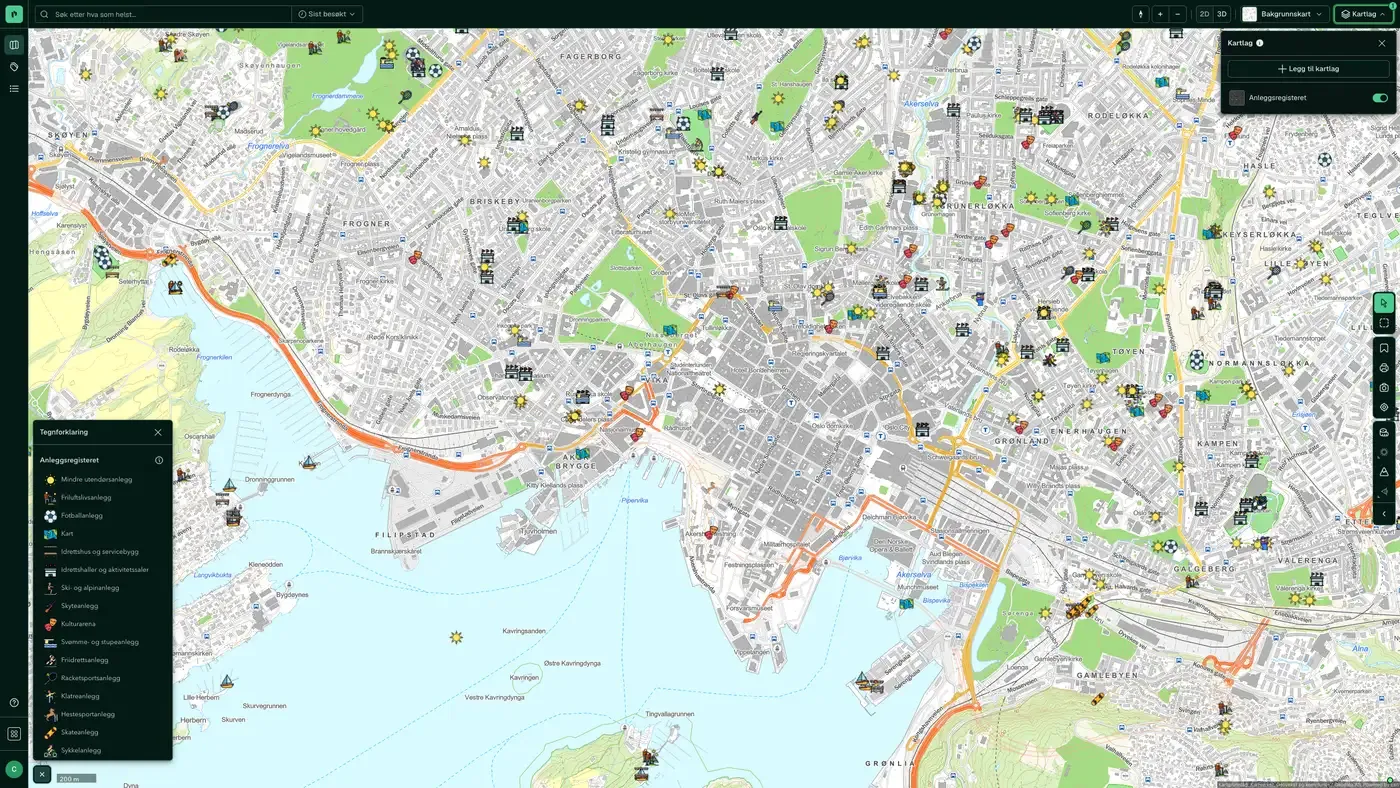
| Facilities register | The Ministry of Culture's facilities register for sports facilities, cultural buildings, outdoor recreation facilities and grants. | Kultur- og likestillingsdepartementet (KUD) |
| Buildings in 3D | Contains buildings across Norway, derived from FKB, aerial photos and LiDAR (laser) data | Geodata AS |
| EU-Taxonomy-Buildings | Used in taxonomy reports for completed buildings | Geodata AS |
| Leasehold land | Plots leased from a land owner to a leaseholder or tenant | Geodata AS |
| Historical aerial photos | Historical aerial photos, one option per year from 1950 to 2026, plus the latest available imagery. | Geodata AS |
Layer by layer
What each layer shows
Cadastre – Property Map
Parcels (delimited areas/plots of land) with information about which property they belong to. Data from Kartverket. The layer is made up of several sublayers: parcels (cadastre number, property boundary, helper line, boundary point), construction projection polygons, address, access and buildings. Turn them on and off individually through Hide/show in Active Layers.
Lessees
Leasehold is part of a land property with a lease relationship between the landowner and the leaseholder. Data from Kartverket. Dataset: Lessees. A leasehold plot is part of a land property where there is a lease relationship between a landowner and a leaseholder/tenant.
Places name
Names of geographic features in Norway, based on map series, economic base maps, nautical charts and city names. Data from Kartverket. The layer contains seven groups of sublayers: settlement, public administration, infrastructure, sea and fresh water, terrain, culture and land cover. Each group has polygon, point and line variants.
Military camps
Properties over 10,000 m² owned by Forsvarsbygg. Data from Geodata AS. The map layer shows properties over 10,000 m² owned by Forsvarsbygg.
Public and similar buildings
All building types linked to public or similar buildings from Matrikkelen. The layer has polygon and point sublayers. Shows all building types linked to public or similar use from Matrikkelen. Building geometry comes from FKB. School and research Kindergarten Primary school Lower secondary school Combined primary and lower secondary school Secondary school Other university, university college and research building University/university college with auditorium, reading room, etc. Library, media centre Other school building Laboratory building Life and health Residential and treatment centre Residential and service centre Hospital Nursing home Other nursing home Other primary health building Clinic, doctor's office/centre/out-of-hours service/animal hospital Rehabilitation institution, spa Health and social centre, health clinic Fire station, ambulance station Police station
Sports, culture & religious buildings
Building types for sports, culture and religion from Matrikkelen. The layer has polygon and point sublayers. Shows all building types linked to sports, culture and religion from Matrikkelen. Building geometry comes from FKB. Sports Sports hall Stand and sports changing rooms Other sports building Playground Swimming pool Ice rink Culture Nightclub Cinema building, theatre building, opera house/concert hall Museum, art gallery Other cultural centre Other museum and library building Monument Community centre, local hall Zoological and botanical garden Religion Prayer house, parish hall Church, chapel Other building for religious activities Monastery Synagogue and mosque Crematorium, funeral chapel, mortuary
Agriculture and fisheries buildings
Buildings linked to agriculture and fisheries from Matrikkelen. The layer has polygon and point sublayers. Shows all building types linked to agriculture and fisheries from Matrikkelen. Building geometry comes from FKB. Agriculture Greenhouse Building for animals/agriculture, storage/silo Other agricultural building Mountain farm building, hut, fisherman's cabin etc. Forest and outfield cabin, turf hut Fisheries Other fishing and hunting building Operating building for fishing/hunting/aquaculture Boathouse, equipment shed for fishing Boathouse, boat shed, sea shed
Infrastructure buildings
Buildings with infrastructure purposes from Matrikkelen. The layer has polygon and point sublayers. Shows all building types linked to infrastructure from the matrikkel. Building geometry comes from FKB. Transport Traffic supervision building Lighthouse station, pilot station Railway and metro station Other dispatch and terminal building Dispatch building, air terminal, control tower Other road and traffic supervision building Water and sewage Building for water supply Building for treatment plant Public toilet Parking Other garage/hangar building Multi-storey car park
Commercial buildings
Building types linked to business from Matrikkelen. The layer has polygon and point sublayers. Shows all building types linked to business use from the matrikkel. Building geometry comes from FKB. Retail trade Shop building Shopping mall, department store Fuel station Fitness studio Exhibition and congress building Bank building, post office building Industry Factory building Workshop building Other industrial building Central kitchen, canteen building Warehouse and logistics Warehouse hall Other storage building Cold and freezer storage Postal terminal Freight terminal Food and accommodation Camping/rental cabin Hotel building Motel building Hostel, guest house Other hotel building Apartment Other building for accommodation Restaurant building, cafe building Street food outlet, kiosk building Other restaurant building Office Office and administration building, town hall Other office building Media building Other commercial building
Apartment building
All housing types from Matrikkelen. The layer has polygon and point sublayers. Shows all building types linked to housing from Matrikkelen. Building geometry comes from FKB. Residential houses Detached house Farmhouse Farmhouse semi-detached house – vertically divided Farmhouse semi-detached house – horizontally divided Detached house with bedsit/basement flat Semi-detached house Semi-detached house, vertically divided Semi-detached house, horizontally divided Apt. buildings Large detached residential building, 2 floors Large detached residential building, 3–4 floors Large detached residential building, 5 floors or more Large connected residential building, 2 floors Large connected residential building, 3–4 floors Large connected residential building, 5 floors or more Terraced block Townhouse etc. Townhouse Linked/atrium house Other small houses with 3 dwellings or more Holiday Home Cabins, summer houses and similar holiday buildings Garage, outhouse, annex to holiday home Year-round home used as a holiday building Farmhouse used as a holiday building Hostel/holiday home Other Student housing Residential barracks Other residential building (secondary home, reindeer herding) Other building for shared housing
Developer activity
Areas with ongoing or planned building activity (building changes are not included). Data from Kartverket. Areas with ongoing or planned new construction (building changes are not included), based on data from Matrikkelen.
Building age
A detailed picture of the age of buildings across Norway, based on data from Matrikkelen. Building geometry comes from FKB. Data from Kartverket. The map layer gives a detailed picture of the age of residential buildings across Norway, based on data from Matrikkelen.
Coverage Map Case Access
Municipalities that Placepoint collects postal lists from, including population figures and the number of documents. Data from Placepoint. Shows all municipalities where Placepoint collects postal lists, together with population figures and the number of available documents. Municipalities with postal lists let you go directly to case access from any property and monitor case access in projects.
Cultural heritage - Askeladden WMS
All cultural heritage data from Riksantikvaren (the national cultural heritage database Askeladden). The layer contains five sublayers: protection zones, localities, individual heritage sites, locality icons and individual monument icons.
Regulation plan proposals
A geographic information service with digital map data for ongoing or proposed zoning plans. Data from the municipalities. The layer is organised into five vertical levels (below ground, on ground/water surface, above ground, on the bottom, in the water column). Each level has sublayers for land-use purpose, consideration zones/designated areas, legal line, regulated height, legal point, annotation and plan area.
Housing and area reserve (Oslo)
An overview of zoned housing in Oslo, with both detailed zoning plans and area zoning plans. Data from Oslo kommune. Overview of zoned housing capacity in Oslo, including detailed and area zoning plans.
Zoning Plans
See Zoning Plans under the Zoning category for the full description and sublayers.
Municipal plans
The municipality's overarching governing document. Data from the municipalities. The land-use purposes mostly use the same colours as the zoning plans, see the zoning plan legend. The layer contains two sublayers: municipality plan and municipal sub-plan. Both have sublayers for land-use purpose, consideration zones/designated areas, boundaries and legal lines, plan area, legal points and annotations.
Property prices
Average property prices distributed across the basic statistical units. Data from Geodata / Eiendomsverdi. Average property prices spread across grunnkretser.
Number of transactions (property)
The number of property transactions per basic statistical unit. Data from Geodata AS. Number of property transactions spread across grunnkretser.
Latest sales (units of use)
Sales of homes and holiday homes in the last 12 months, minimum purchase sum 100,000 kr. Gives a visual picture of market activity in the neighbourhood. Borettslag are not included. Data from Kartverket. Sales of homes and holiday homes in Matrikkelen in the last 12 months. The lowest purchase sum is 100,000 kr. Price per square metre is included where it can be calculated. Borettslag are not included.
Buildings in 3D
Contains buildings across Norway, derived from FKB, aerial photos and LiDAR data (laser). All the buildings are drawn in the same colour. The colour comes from the default style for 3D buildings and says nothing about building type, age or use. To tell buildings apart, change the style or create your own under Background Map in the top bar, in the 3D Settings tab (see How to use map layers). Click a building to see its building type from the matrikkel in the Building panel.
EU-Taxonomy-Buildings
Used in taxonomy reporting for completed buildings. Used in taxonomy reporting for completed buildings.
Leasehold land
Parcels leased from a landowner to a leaseholder/tenant. Updated daily. Parcels leased from a landowner to a leaseholder/tenant. Updated daily.
Historical aerial photos
Aerial photos back in time, with one option per year. Enable one year at a time to see the area as it looked that year, and switch between years to date building work, terrain interventions, old road alignments, fills and earlier land use. The layer has 78 sublayers: Latest imagery, which shows the best available imagery for the area, and one option per year from 1950 to 2026. Latest imagery is on when you add the layer; the years are off until you select one, and they are meant to be used one at a time.
The datasets behind
Datasets in Property
Number of transactions (property)
The number of registered property transactions per basic statistical unit over a given period, based on the matrikkel.
About the datasetHousing and area reserve (Oslo)
Oslo kommune's own overview of zoned housing in the capital: a compiled zoning reserve that covers both detailed zoning plans (individual projects) and area zoning plans (larger areas).
About the datasetApartment building
All building types classed as housing in the matrikkel, with building geometry from Felles kartdatabase (FKB).
About the datasetBuildings in 3D
Contains buildings across Norway, derived from FKB, aerial photos and LiDAR data (laser).
About the datasetBuilding age
Detailed overview of the year buildings across Norway were built, based on the information municipalities have registered in the matrikkel, with building geometry from Felles kartdatabase (FKB).
About the datasetCoverage Map Case Access
Shows which municipalities we collect public records lists from to power the Saksinnsyn feature.
About the datasetProperty prices
Average property price per basic statistical unit, based on compiled transaction data from Eiendomsverdi, Kartverket's matrikkel and Statistics Norway (SSB).
About the datasetEU-Taxonomy-Buildings
Used in taxonomy reporting for completed buildings.
About the datasetLeasehold land
Parcels leased from a land owner to a leaseholder/tenant.
About the datasetHow do I turn on the Property layers in Fusion?
Click Map layers at the top right of the map, select the category in the list on the left and turn on the layer. You can have several layers on at once, over the same property.
Where do the layers come from?
The sources are listed in the table above, including Kartverket. Dataset: Cadastre – Property Map, Kartverket, Kartverket. Dataset: Places name, Geodata AS. Dataset: Military camps. Each layer shows its source and date.
Can I get the same data programmatically?
Yes. The datasets behind the layers are available in the Placepoint API and in Placepoint AI through MCP.
Other categories
The layers and descriptions come from the documentation, synced 16 October 2026.
Used where decisions really matter







