









Datasets · Infrastructure
Post offices and postal locations, already linked to every property.
Locations of post offices and post-in-shop outlets in Norway. Posten Norge closed most traditional post offices in several rounds. Today, most postal distribution runs as "Post i butikk" (post in shop) through Joker, Coop, Bunnpris and similar grocery chains.
What the dataset contains
Post offices and postal locations in Placepoint
Locations of post offices and post-in-shop outlets in Norway. Posten Norge closed most traditional post offices in several rounds. Today, most postal distribution runs as "Post i butikk" (post in shop) through Joker, Coop, Bunnpris and similar grocery chains. The dataset includes both the remaining standalone post offices and post-in-shop locations. Supplied by Geodata AS, with the Enhetsregister (Central Coordinating Register for Legal Entities) at Brønnøysundregistrene as the underlying source for company details.
For housing developers and commercial agents, a post office is a moderate factor in how attractive a location is. In a small village, it can still be one of the most important everyday services. Part of our Business map layers. Related: Grocery Chains (many postal locations are inside the chains' shops).
This text is based on the dataset documentation, synced 16 October 2026.
What it looks like
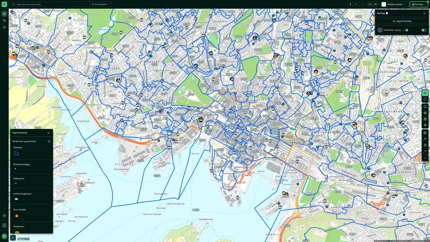
Post offices and postal locations on the map
The dataset is part of the Infrastructure map layer:
Source: Posten Bring. Last updated 9 September 2026
More in the Infrastructure map layer
Datasets often read together
Fuel stations
All fuel stations in Norway with chain affiliation (Circle K, Shell, Esso, YX, Best, Uno-X and others), number of employees and accounts data.
About the datasetBroadband coverage
Broadband coverage per building, grouped into speed classes.
About the datasetBridges
All bridges and bridge-like structures in Norway, taken from the Norwegian Public Roads Administration's National Road Database (NVDB): planned, newly built, demolished, in use, not in use and closed or blocked.
About the datasetFibre coverage
Share of households offered 1 Gbit/s fibre, from Nkom's annual coverage survey.
About the datasetMunicipality Borders
Norway's 357 municipalities with municipality number (four-digit code) and official outer boundaries.
About the datasetManhole cover, drain and hydrant
Visible points on the municipal water and sewage network: manholes, gullies and fire hydrants, taken from LedningVA in Felles kartdatabase (FKB).
About the datasetHow often are post offices and postal locations updated?
Weekly. The frequency follows the source and is shown on the dataset in Placepoint.
Where does the data come from?
From Geodata AS and Posten Bring. We collect and quality-check the data and link it to the right property, with source and date on every field.
How do I see post offices and postal locations for a property?
Look up the address in Fusion and turn on the Infrastructure map layer. The dataset is there as its own layer, and the details appear in the property panel when you click on the map.
Can I get the dataset programmatically?
Yes. The same data is available in Placepoint API and in Placepoint AI through MCP, so you can bring it into your own systems and agents.
Used where decisions really matter







