









Datasets · Infrastructure
Manhole cover, drain and hydrant, linked to every property.
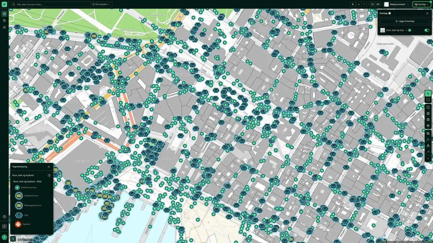
Visible points on the municipal water and sewage network (manholes, drains and fire hydrants) taken from LedningVA in Felles kartdatabase (FKB, the common map database). The dataset contains only what is visible at ground level, not the full underground pipe network.
What the dataset contains
Manhole cover, drain and hydrant in Placepoint
Visible points on the municipal water and sewage network (manholes, drains and fire hydrants) taken from LedningVA in Felles kartdatabase (FKB, the common map database). The dataset contains only what is visible at ground level, not the full underground pipe network. Distributed by Norges vassdrags- og energidirektorat (NVE, the Norwegian Water Resources and Energy Directorate), with Kartverket managing FKB.
For developers and designers, the dataset helps with connections to public water and sewage, and with locating fire hydrants for TEK17 assessments of firefighting water coverage. The full pipe network (including trench positions for buried pipes) is not open information: contact the kommune to have cables and pipes located before you dig. Included in the Infrastructure map layers in Placepoint. Related: Water & sewer assets along roads, Wastewater facilities.
Continuously by Kartverket, and changes show up in Placepoint straight away.
This text is based on the dataset documentation, synced 16 October 2026.
More in the Infrastructure map layer
Datasets often read together
Fuel stations
All fuel stations in Norway with chain affiliation (Circle K, Shell, Esso, YX, Best, Uno-X and others), number of employees and accounts data.
About the datasetBroadband coverage
Broadband coverage per building, grouped into speed classes.
About the datasetBridges
All bridges and bridge-like structures in Norway, taken from the Norwegian Public Roads Administration's National Road Database (NVDB): planned, newly built, demolished, in use, not in use and closed or blocked.
About the datasetFibre coverage
Share of households offered 1 Gbit/s fibre, from Nkom's annual coverage survey.
About the datasetMunicipality Borders
Norway's 357 municipalities with municipality number (four-digit code) and official outer boundaries.
About the datasetPost offices and postal locations
Locations of post offices and post-in-shop outlets in Norway.
About the datasetHow often is manhole cover, drain and hydrant updated?
Real time. The update frequency follows the source and is shown on the dataset in Placepoint.
Where does the data come from?
From Norges vassdrags- og energidirektorat. We collect and quality-check the data, then link it to the right property, with source and date on every field.
How do I see manhole cover, drain and hydrant on a property?
Look up the address in Fusion and turn on the Infrastructure map layer. The dataset is there as its own layer, and the details appear in the property panel when you click on the map.
Can I get the dataset programmatically?
Yes. The same data is available in Placepoint API and in Placepoint AI through MCP, so you can bring it into your own systems and agents.
Used where decisions really matter







