









Map layers · 9 layers
Education, layer by layer over the property.
The Education category shows kindergartens, primary, lower secondary and upper secondary schools, school catchment areas and education demographics for the population. The layers are useful when families with children assess a home purchase, when designing housing projects where being close to a school and kindergarten is a selling point, and when assessing the education profile of a recruitment market.
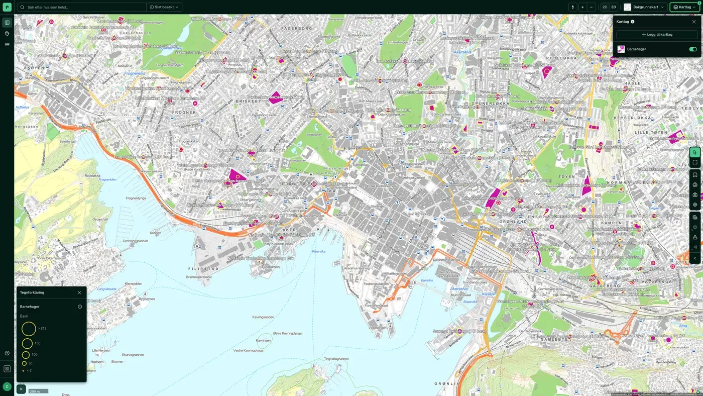
The layers
9 layers in Education
| Layer | Description | Source |
|---|---|---|
| Kindergartens | All kindergartens in Norway with capacity and contact details | Utdanningsdirektoratet (Udir) |
| Primary Schools | Public and private primary and lower secondary schools | Norwegian Directorate for Education and Training (Udir). Datasets: Primary Schools |
| Upper secondary schools | Public and private upper secondary schools | Utdanningsdirektoratet (Udir) |
| School catchment areas | Geographic school catchment areas across Norway | Kartverket |
| Catchment area: primary and combined schools in Bergen | Catchment boundaries for primary schools in Bergen | Bergen Municipality. Datasets: Catchment areas for schools in Bergen |
| Catchment area: lower secondary schools in Bergen | Catchment boundaries for lower secondary schools in Bergen | Bergen kommune |
| Public and similar buildings | Public buildings from the matrikkel | Kartverket |
| Education Level | Share of population by education level per basic statistical unit | Statistisk sentralbyrå (SSB) |
| Field of education | Dominant field of education per basic statistical unit | Statistisk sentralbyrå (SSB) |
Layer by layer
What each layer shows
Kindergartens
All kindergartens in Norway from barnehagefakta.no (the Utdanningsdirektoratet API). Click a point to see the kindergarten's name, capacity and contact details. Useful for checking kindergarten coverage within walking distance of a residential property, or for planning kindergarten admission when relocating. The data comes from the Utdanningsdirektoratet API for kindergartens from www.barnehagefakta.no. Barnehagefakta is based on information the kindergartens report themselves, and is quality assured by the kommune and Utdanningsdirektoratet. Reporting to Barnehagefakta takes place annually, but the information may have changed since the figures were reported. Kindergartens that only have a postcode as their address may have an approximate position.
Primary Schools
Public and private primary and lower secondary schools with address and contact details from Utdanningsdirektoratet (Udir). Combine with School catchment areas to see which school a property belongs to. Public and private primary and lower secondary schools. For some schools the positional accuracy may deviate. The data in Nasjonalt skoleregister (the national school register) is updated based on information from Virksomhets- og foretaksregisteret (VoF)/Brønnøysundregistrene, Grunnskolens informasjonssystem (GSI) and other sources. GSI records the situation as of 1 October each year. Data becomes publicly available in GSI at the end of December, which means that information in NSR may have changed since the previous update.
Upper secondary schools
Public and private upper secondary schools with address and contact details from Utdanningsdirektoratet (Udir). Useful for assessing access to upper secondary education from a district, or for mapping the pupil base in a recruitment market. Datasets: Upper secondary schools. Public and private upper secondary schools in Norway with related contact details. For some schools the positional accuracy may deviate. The data in Nasjonalt skoleregister (the national school register) is updated based on information from Virksomhets- og foretaksregisteret (VoF)/Brønnøysundregistrene, Grunnskolens informasjonssystem (GSI) and other sources. GSI records the situation as of 1 October each year. Data becomes publicly available in GSI at the end of December, which means that information in NSR may have changed since the previous update.
School catchment areas
Geographic boundaries for school catchment areas across Norway from the kommuner. Important for families with children: the address decides which school the child belongs to, and the catchment boundary can change at block level. Combine with Primary Schools to see the relevant school, and with Kindergartens for everyday logistics. School catchment areas across Norway.
Catchment – Primary/combined schools (Bergen)
Bergen kommune's catchment boundaries for primary schools and combined schools from Bergen kommune. Functionally the same as school catchment areas, but with Bergen kommune's own boundaries. National school catchment areas do not always cover Bergen correctly. Bergen's catchment areas for primary and combined schools are made available here (they are not shared nationally). Updated directly from the kommune.
Catchment – Lower secondary (Bergen)
Bergen kommune's catchment boundaries for lower secondary schools. See the comment under the primary school catchment area. Bergen's catchment areas for lower secondary schools are made available here (they are not shared nationally). Updated directly from the kommune.
Public and similar buildings
All building types linked to public purposes from Matrikkelen: schools, kindergartens, town halls, health buildings and similar. Supplements the school and kindergarten layers with the physical building instead of the institution. Shows all building types linked to public or similar use from Matrikkelen. Building geometry comes from FKB. School and research Kindergarten Primary school Lower secondary school Combined primary and lower secondary school Secondary school Other university, university college and research building University/university college with auditorium, reading room, etc. Library, media centre Other school building Laboratory building Life and health Residential and treatment centre Residential and service centre Hospital Nursing home Other nursing home Other primary health building Clinic, doctor's office/centre/out-of-hours service/animal hospital Rehabilitation institution, spa Health and social centre, health clinic Fire station, ambulance station Police station
Education Level
Shows the share of the population per grunnkrets (basic statistical unit) with different education levels (primary school, secondary, university college/university lower and higher). Data from Statistisk sentralbyrå (SSB). The layer is also in the Demographics category. Datasets: Education Level. The population's highest completed education, for residents aged 16 and over (plus 15-year-olds who have completed primary school or started upper secondary education).
Field of education
Shows the dominant field of education among people living in the grunnkrets (technical subjects, health and social care, business/administration, and so on). Useful for characterising the workforce profile in a recruitment market. Data from Statistisk sentralbyrå (SSB). The layer is also in the Demographics category. Datasets: Field of education. Dominant field of education per grunnkrets. Categories: Allmenne fag, Helse- og sosialfag, Humanistiske og estetiske fag, Lærerutdanning, Naturvitenskap, Økonomiske fag, Primærnæringer, Samferdsel, Samfunnsfag and Uoppgitt.
The datasets behind
Datasets in education
Kindergartens
All kindergartens in Norway from Barnehagefakta, the public kindergarten database run by Utdanningsdirektoratet (the Norwegian Directorate for Education and Training).
About the datasetPrimary Schools
All public and private primary and lower secondary schools in Norway, from Nasjonalt skoleregister (NSR), the national school register run by Utdanningsdirektoratet.
About the datasetSchool catchment areas
School catchment areas show which primary and lower secondary schools a specific home belongs to under the municipality's admission rules.
About the datasetUpper secondary schools
All public and private upper secondary schools in Norway from Nasjonalt skoleregister (NSR), run by Utdanningsdirektoratet, with contact information, ownership form, number of pupils and county.
About the datasetHow do I turn on the education layers in Fusion?
Click Map layers at the top right of the map, select the category in the list on the left and turn on the layer. You can have several layers on at once, over the same property.
Where do the layers come from?
The sources are listed in the table above, including Utdanningsdirektoratet (Udir), Utdanningsdirektoratet (Udir). Datasets: Primary Schools, Kartverket, Bergen kommune. Datasets: Catchment areas for schools in Bergen. Each layer shows its source and date.
Can I get the same data programmatically?
Yes. The datasets behind the layers are available in the Placepoint API and in Placepoint AI through MCP.
Other categories
The layers and descriptions come from the documentation, synced 16 October 2026.
Used where decisions really matter







