









Datasets · Transport and communications
Road transport – classes & constraints, already linked to every property.
Detailed dataset for planning heavy transport, from Statens vegvesen's Nasjonal vegdatabank (NVDB). Includes:
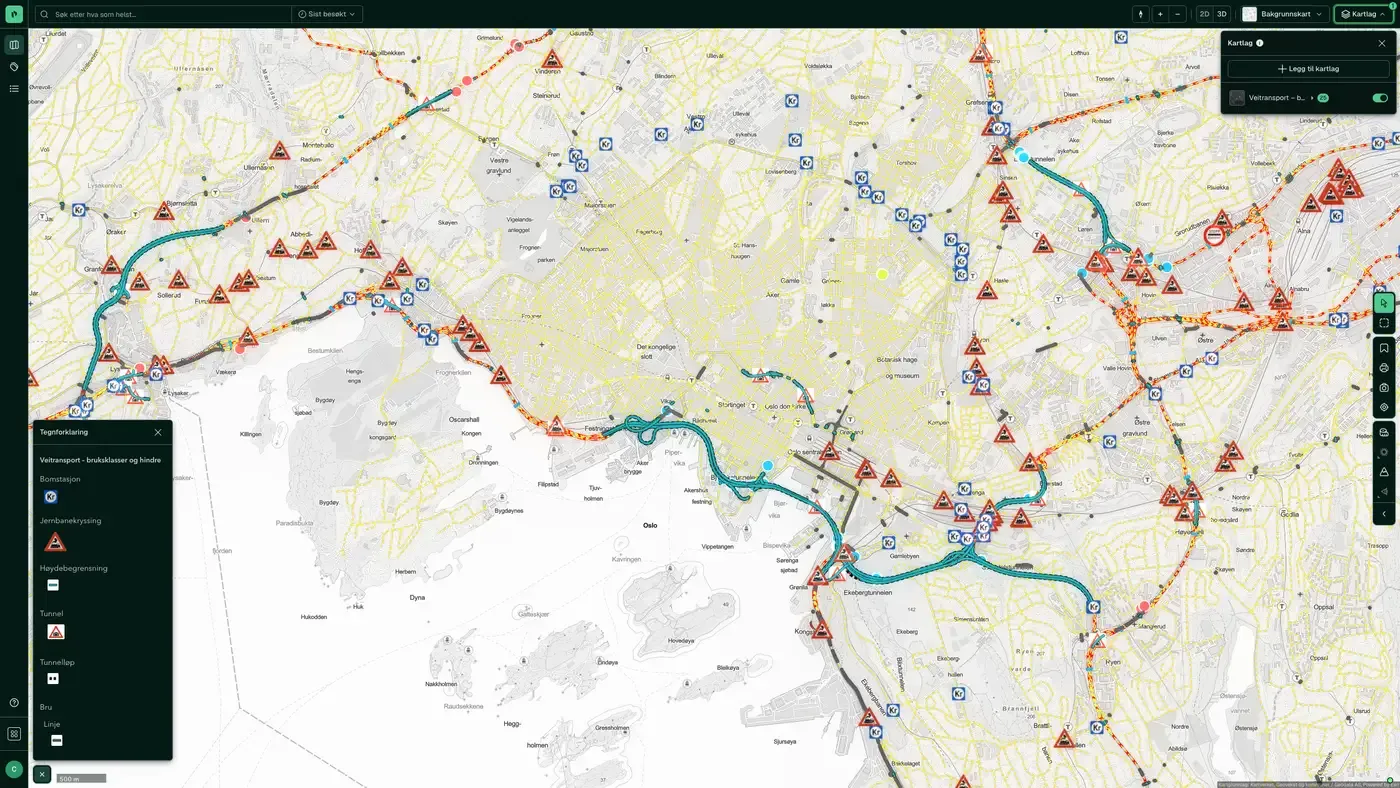
What the dataset contains
Road transport – classes & constraints in Placepoint
Detailed dataset for planning heavy transport, from Statens vegvesen's Nasjonal vegdatabank (NVDB). Includes:
Road use classes for different vehicle types: timber transport (vehicle combinations up to 24 m and 60 tonnes on selected routes), mobile cranes (road list 12/65), modular vehicle combinations (road list 12/100), special transport (12/100 with exemption) and normal transport. The lists are updated every six months.
Barriers: physical road closures where there is a risk of landslides, at tunnels or in high mountain areas.
Rest areas, inspection and weighing stations, ferry quays and daily rest stops: infrastructure set up for heavy transport.
Bridges, tunnels, height restrictions, railway crossings and toll stations: obstacles that affect access.
Speed limits: the highest permitted speed on each stretch of road.
For a developer of logistics or industrial property, road use classes are decisive: a warehouse property without access by a road certified for vehicle combinations is practically impossible to serve. For housing developers, the dataset matters less for the property itself, but it can signal the quality of the area's road network. Part of Placepoint's Transport and communications and Infrastructure map layers. Related: Road category, authority & speed limit, Bridges.
This text is based on the dataset documentation, synced 16 October 2026.
More in the Transport and communications map layer
Datasets often read together
Cars age
Average age of privately owned cars in an area, based on Statens vegvesen's motor vehicle register.
About the datasetCars and fuel types
Number of cars per fuel type in each area, based on Statens vegvesen's motor vehicle register.
About the datasetCars brands
Heat map of car density with the breakdown by car brand, based on Statens vegvesen's motor vehicle register.
About the datasetCars types
Number of cars per vehicle type in each area, based on Statens vegvesen's motor vehicle register.
About the datasetBuilding Limits from the Road's Center Line
The Roads Act sets general building limits measured from the centre line of all public roads. This legal boundary sets how close to the road you can build without a specific exemption.
About the datasetElectric cars
Number of privately owned electric cars per 100 x 100 m grid cell, taken from Statens vegvesen's motor vehicle register and anonymised and aggregated.
About the datasetHow often is road transport – classes & constraints updated?
Weekly. Road use classes for different vehicle types: timber transport (vehicle combinations up to 24 m and 60 tonnes on selected routes), mobile cranes (road list 12/65), modular vehicle combinations (road list 12/100), special transport (12/100 with exemption) and normal transport. The lists are updated every six months.
Where does the data come from?
From Statens vegvesen. We collect and quality-check the data, then link it to the right property, with source and date on every field.
How do I see road transport – classes & constraints for a property?
Look up the address in Fusion and turn on the Transport and communications map layer. The dataset has its own layer, and the details appear in the property panel when you click on the map.
Can I get the dataset programmatically?
Yes. The same data is available in Placepoint API and in Placepoint AI through MCP, so you can bring it into your own systems and agents.
Used where decisions really matter







