









Datasets · Risk
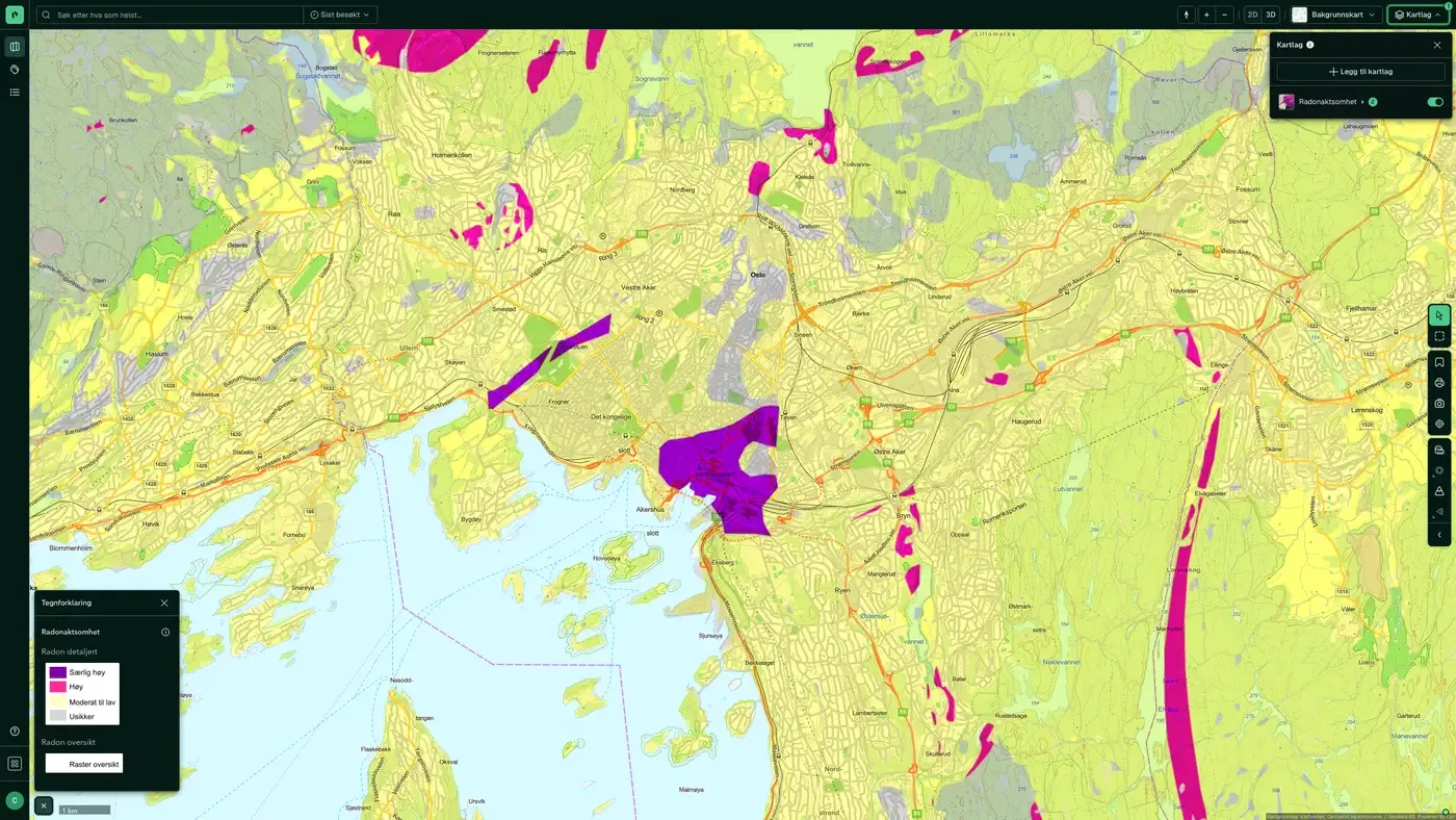
Radon map: check whether a plot or home is in a radon-prone area.
Areas in Norway that are likely to be more radon-prone than others. Based on the national indoor air measurement database from Statens strålevern (NRPA) and NGU's bedrock and loose masses databases. Distributed to Placepoint by Geodata AS.
What the dataset contains
Radon susceptibility in Placepoint
Areas in Norway that are likely to be more radon-prone than others. Based on the national indoor air measurement database from Statens strålevern (NRPA) and NGU's bedrock and loose masses databases. Distributed to Placepoint by Geodata AS. Radon is a radioactive gas that seeps up through the ground and can build up indoors. After smoking, it is one of the most important single causes of lung cancer in Norway.
For developers and designers, the radon map is a required check: buildings on radon-prone plots must be designed with a radon barrier in the ground and ventilation ducts under TEK17 § 13-5. For agents, brokers and surveyors, it is information that belongs in the sales prospectus and valuation. Read the dataset alongside Radon probability (a parallel model from NVE), Bedrock and Loose masses. Part of our Risk map layers.
This text is based on the dataset documentation, synced 16 October 2026.
More in the Risk map layer
Datasets often read together
Caution surfaces, (regulated) water, dams
NVE's flood awareness map: a coarser first assessment of where flood hazard should be investigated further.
About the datasetFire Stations Response Time
Placepoint's derived analysis of all fire stations in Norway with their driving response time zones: 5, 10 and 20 minutes, calculated from each station.
About the datasetFlood hazard map
The Flood hazard map shows areas that flood at different flood sizes (return periods).
About the datasetHigh tide / storm surge
Modelled storm surge and sea level rise zones for Norway's coast, supplied to Placepoint by Geodata AS.
About the datasetQuick clay
Quick clay is a particular type of marine clay that loses all its bearing capacity when disturbed or loaded. It is the single factor in Norwegian geotechnics that most often stops development projects or makes them more expensive.
About the datasetQuick Clay – Caution
Shows areas that may be exposed to quick clay landslides, based on marine clay deposits and terrain criteria (slope and height difference).
About the datasetHow to do it in Fusion
Radon susceptibility for a property, step by step
Search for the address
Or the plot you are considering.
Turn on Radon susceptibility
Under Risk in the map layer picker. Radon probability from NVE is next to it.
Read the zone in the panel
The property panel marks the areas the plot touches.
Check the geology
Bedrock and loose masses from NGU explain why.
How do I check radon for an address?
Search for the address in Placepoint and turn on the Radon susceptibility layer under Risk. The property panel shows whether the plot is in an area of high susceptibility. The map does not replace a measurement in the home itself.
What does high radon susceptibility mean?
At least 20% of homes in the area are estimated to have radon above 200 Bq/m³. Areas with alum shale in the ground have particularly high susceptibility.
Can the map tell me anything about my home?
No. The resolution is no better than 1:50,000, and the only reliable way to know the radon level in a home is to measure it. The map is a first assessment for planning and design.
What does TEK17 require for radon?
Buildings on radon-prone plots must be designed with a radon barrier in the ground and ventilation ducts under TEK17 § 13-5.
How often is radon susceptibility updated?
Monthly. The frequency follows the source and is shown on the dataset in Placepoint.
Where does the data come from?
From Geodata AS. We collect and quality-check the data and place it on the correct property, with source and date on every field.
How do I see radon susceptibility for a property?
Look up the address in Fusion and turn on the Risk map layer. The dataset is there as its own layer, and the details appear in the property panel when you click on the map.
Can I get the dataset programmatically?
Yes. The same data is available in Placepoint API and in Placepoint AI through MCP, so you can bring it into your own systems and agents.
Used where decisions really matter







