









Datasets · Risk
Quick clay: what it is, and how to check whether your plot lies in a zone.
Quick clay is a particular type of marine clay that loses all its load-bearing capacity when disturbed or loaded. It is the single factor in Norwegian geotechnics that most often stops development projects or makes them more expensive. The dataset is managed by Norges vassdrags- og energidirektorat (NVE) and combines two layers that used to be supplied separately.
What the dataset contains
Quick clay in Placepoint
Quick clay is a particular type of marine clay that loses all its load-bearing capacity when disturbed or loaded. It is the single factor in Norwegian geotechnics that most often stops development projects or makes them more expensive. The dataset is managed by Norges vassdrags- og energidirektorat (NVE) and combines two layers that used to be supplied separately.
This text is based on the dataset documentation, synced 16 October 2026.
What it looks like
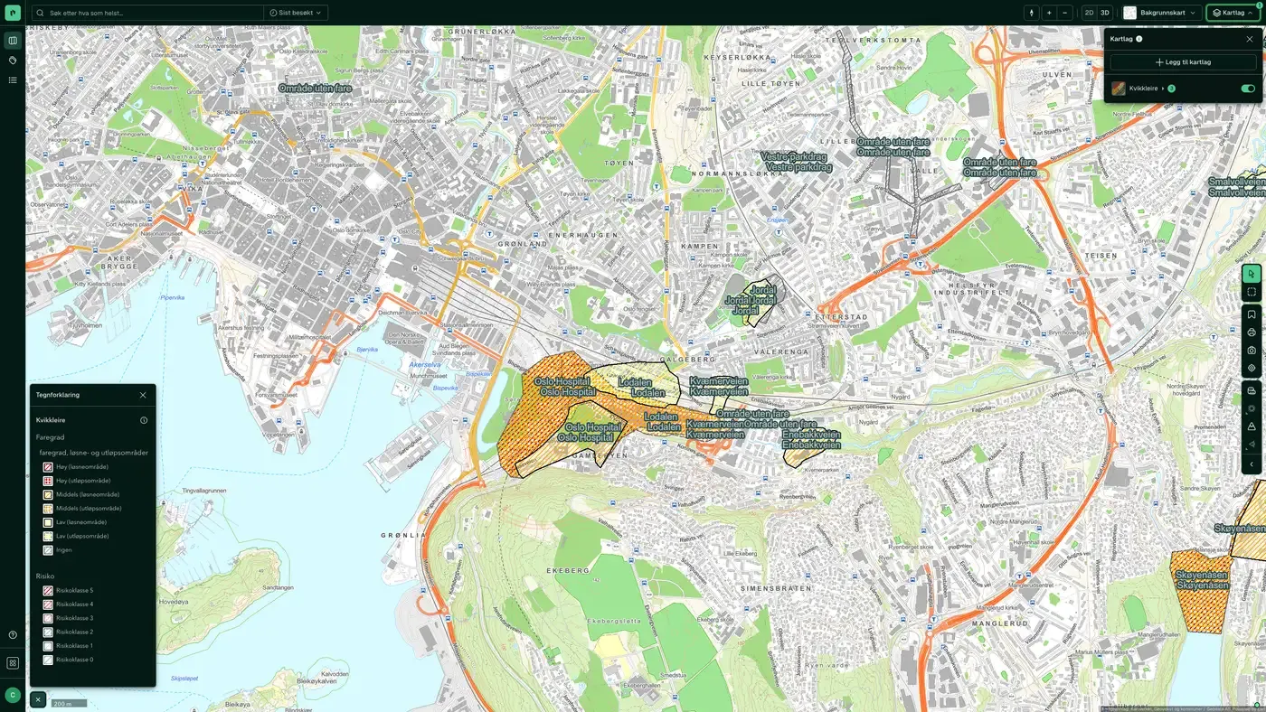
Quick clay on the map
The dataset is part of the map layer Risk:
Source: Norges geologiske undersøkelse (NGU). Last updated 9 September 2026
More in the Risk map layer
Datasets often read together
Caution surfaces, (regulated) water, dams
NVE's flood awareness map: a coarser first assessment of where flood hazard should be investigated further.
About the datasetFire Stations Response Time
Placepoint's derived analysis of all fire stations in Norway with their driving response time zones: 5, 10 and 20 minutes, calculated from each station.
About the datasetFlood hazard map
The Flood hazard map shows areas that flood at different flood sizes (return periods).
About the datasetHigh tide / storm surge
Modelled storm surge and sea level rise zones for Norway's coast, supplied to Placepoint by Geodata AS.
About the datasetQuick Clay – Caution
Shows areas that may be exposed to quick clay landslides, based on marine clay deposits and terrain criteria (slope and height difference).
About the datasetRadon susceptibility
Areas in Norway that are likely to be more exposed to radon than others, based on the Norwegian Radiation Protection Authority's (NRPA) national database of indoor air measurements and NGU's bedrock and superficial deposit databases.
About the datasetHow to do it in Fusion
Quick clay on a property, step by step
Search for the plot
Address or cadastre number.
Turn on the risk layers
Quick clay, Quick Clay – Caution, Marine border and Loose masses.
Read the zones in the panel
The property panel shows which zones the plot touches, with source and date.
Get the report
Risk and climate risk go through the ground conditions, from the marine border to loose masses.
How do I check whether there is quick clay on a plot?
Look up the address and add the risk map layers Quick clay and Quick Clay – Caution in Placepoint. The layers are NVE's hazard zones and caution zones, and the property panel marks the zones the plot touches. A zone means a geotechnical assessment is required, not that a landslide is likely.
Where is there quick clay in Norway?
Below the marine border, meaning areas that lay under the sea after the last ice age: large parts of Østlandet, Trøndelag and the coastal lowlands. NGU manages the marine border dataset, and it is a separate layer in Placepoint.
Can you build on quick clay?
Yes, but it requires geotechnical ground investigations and often costly measures such as piling, soil replacement or counterfills. Section 28-1 of the Planning and Building Act (plan- og bygningsloven) requires the building ground to be sufficiently safe.
What is the difference between a hazard zone and a caution zone?
Hazard zones are mapped zones with a hazard level and consequence class. Caution zones are wider areas with marine clay and terrain that make quick clay landslides possible. Both are shown as layers in Placepoint, with NVE as the source.
What happened in Gjerdrum?
The quick clay landslide in Gjerdrum in 2020 tightened the requirements for mapping and risk assessment when building in quick clay areas. The method is set out in NVE guideline 1/2019.
How often is quick clay updated?
Real time. The update frequency follows the source and is shown on the dataset in Placepoint.
Where does the data come from?
From Norges vassdrags- og energidirektorat. We collect and quality-check the data, then link it to the right property, with source and date on every field.
How do I see quick clay on a property?
Look up the address in Fusion and turn on the Risk map layer. The dataset is there as its own layer, and the details appear in the property panel when you click on the map.
Used where decisions really matter







